Blue Mountains mtb rides
St Helena
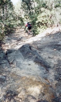
This track is now fast, narrow firetrail with some singletrack extensions. The firetrail is rapidly reverting to dual track in many spots, which is a great sign of things to come! In October 2015 the track was mostly in good condition - lots of litter on the track, but clear lines are available ( old YouTube video - 6:23). The downhills are becoming looser, and it's less friendly for hardtails than it used to be - it's still doable, but I'd feel pretty beat up after a hardtail ride. Confident, fit beginners would probably enjoy a ride to the lookouts and back, but should avoid the Glenbrook extension. I usually have to walk a few of the hills on my way back from the lookouts to Woodford, and sometimes the first big one on St Helena itself.
These days I do this ride as an out and back - Woodford to both lookouts and back. This gives a good 30 km of trail to enjoy. You can still get through to Glenbrook, but as NPWS advise we shouldn't ride the section from the big chute to creek.
The track was bulldozed a few years ago so NPWS could work in St Helena Crater. These days it's mainly narrow firetrail, returning to dual track, and the downhills have plenty of waterbars inviting airtime. The last section is overgrown singletrack.The track to the lookouts and back is not particularly technical - but beginners would be nervous on some of the loose, leaf littered downhills. they'll get a shock when they go from firetrail to overgrown singletrack on their way to the lookout...
Turning off the main Oaks track about five and a half kms from the station, the clearly signposted track heads to St Helena Crater, Bunyan Lookout and Lost World Lookout. The Glenbrook extension returns to civilisation near Glenbrook railway station. On your ride you'll find some good lookouts, some fast firetrail, deep sand traps, steep downhills, some slow, heavily overgrown singletrack, and, if you head to Glenbrook, some walking for all. Yep, all - this route includes the bit we're not allowed to ride, between the chute and the Duckhole. And then there's the climb/carry out.
Eye protection is strongly recommended - the singletrack is overgrown and there are lots of dead sticks just at eye level.
Here's a kml file of the round trip from Woodford to Bunyan and Lost World lookouts. You'll need Google Earth to view. Here's my trace on Garmin's site.
Catch the train to Woodford station and go to the high side carpark - not the highway side. Head back towards Sydney along Railway Parade, until it ends in a "T" intersection (about 300 metres from the station). Turn right here into the Appian Way, then left into Parker Street after about 100 metres, and left into Taylor Road at the "T" intersection (after about 80 metres). After another 50 metres, you'll see a dirt road off to the right, with a locked gate. There are signs here to identify the National Park. This firetrail is The Oaks, a very popular route to Glenbrook. Follow The Oaks firetrail.
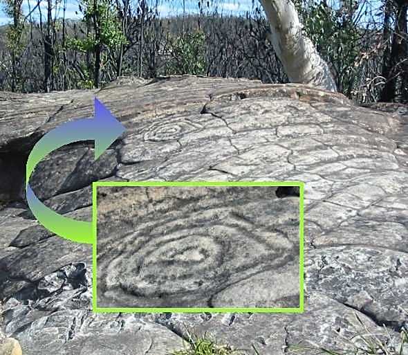
Don't forget to look for the aboriginal carving of concentric circles (circles.jpg) at the top of the first really big hill on The Oaks track. The Circles are visible without leaving the track. National Parks have pushed boulders between the rock shelf and track to keep people off.
KEEP OFF!! sheesh... Shortly after passing The Circles, and about six km from the station, you'll see an obvious, signposted firetrail off to the left. This is the start of the St Helena track.
Over a few small waterbars, round the deep sandy corner and down you go, down the first of many downhill stretches, and it's not long till the biggest uphill on the way to the lookouts. Once at the top, you can breathe easy, knowing that most of the track from here to the lookouts is flat or downhill. Just look at that elevation chart... Of course, that means it's flat or uphill all the way back. That said, and although I find it hard work and walk a bit, the return trip isn't that bad. More of a slow grind than a killer.
 |
After about five km on the St Helena track, enjoying downhills with waterbars, fast flats, and occasional sand traps, you'll come to a bit of a clearing where the track heads hard left. You might notice a singletrack heading straight ahead, and some rocks for sitting on to your right. This is the old fork, an ideal place to wait for friends and to decide if you want to do the lookouts or not. The left hand fork (main firetrail) goes to Bunyan and Lost World Lookouts, as well as St Helena itself. The right hand fork (singletrack, slightly veers right) leads to Glenbrook via the Duckhole. This track looks insignificant compared to the main firetrail. NOTE: NPWS have advised that the legally rideable area of the track to the Duckhole ends at the chute marking the descent to the creek. Walking only allowed. If you want to keep riding, turn around here and return the way you came to the main firetrail - turn left for Glenbrook, or right to go back to Woodford. |
Stay on the fire trail and head to the lookouts. The views are well worth it. The main track now goes goes steeply down into St Helena crater, an eroded volcanic vent and site of a former farm, after heading left at the fork. The track to the lookouts appears as an insignificant sidetrack to the right, starting at the top of the descent into St Helena, and about 12 kilometres from the station. In October 2015, there's an old sign at the top of the final descent into St Helena crater - this is where you turn right onto the singletrack to the lookouts. This section is very overgrown, with lots of face slapping and scratching branches. |
The sign is on the other side of the post - left to Lost World Lookout, right (straight ahead) for Bunyan Lookout. |
A posted track to the left goes to Lost World Lookout, while the main track leads to Bunyan Lookout. I usually arrive at the lookouts itchy and covered in small scratches (and a bit of blood). Both lookouts have great views across Glenbrook Creek to the backs of Springwood and Valley Heights, and to the city in the distance. While it's possible to walk out to Springwood from Bunyan Lookout via Martin's Lookout, don't. It's an absolute shocker of a climb down, and a mongrel going back up with your bike on your shoulder. Definitely not recommended - we were overtaken by walkers going down - we were too slow carrying the bikes...
|
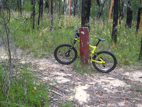
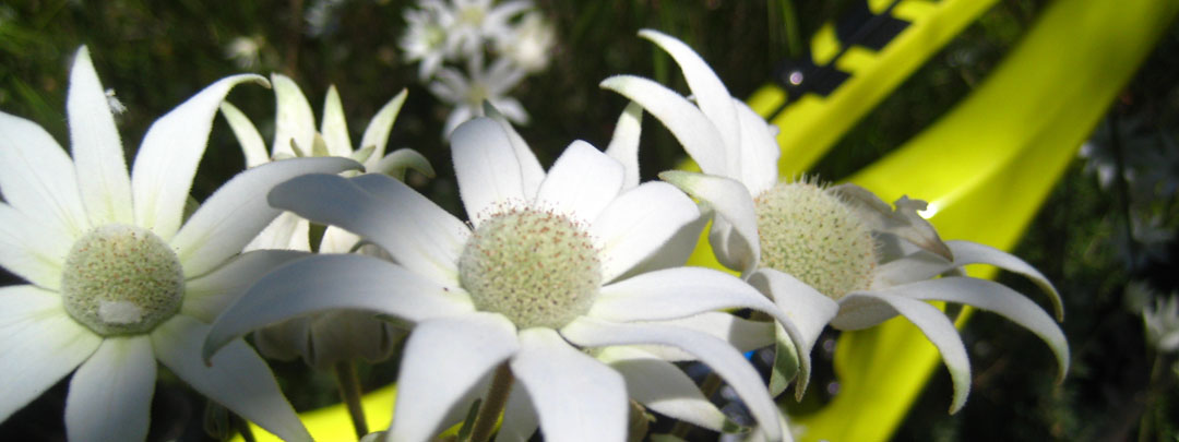
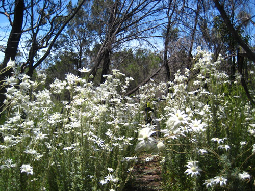
At the right time of year (late spring into early summer), flannel flowers abound along the singletrack. Look closely, and you can see my bike propped up in the middle of the singletrack. The flannel flower is NSW's floral emblem. Beautiful. In October, the air can be heavy with the scent of boronias lining the side of the trail - spring sees lots of different flowers along this track. After visiting both lookouts, I turn around and backtrack to Woodford. |
 |
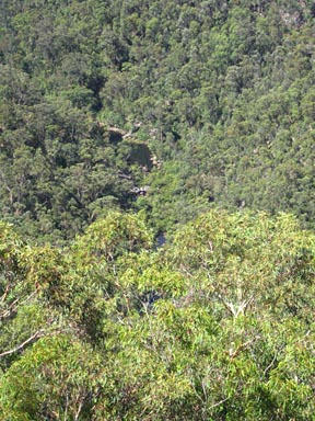 |
That's Glenbrook Creek down there - it's a long way down - and back up! | 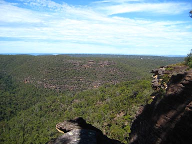 Although the photo is too small to tell, on a clear day you can see Sydney easily from the lookouts - the Harbour Bridge and Centrepoint Tower are clearly identifiable, as are other landmarks. Although the photo is too small to tell, on a clear day you can see Sydney easily from the lookouts - the Harbour Bridge and Centrepoint Tower are clearly identifiable, as are other landmarks. |
Back at the fork and headed to Glenbrook you'll find more of the same - fun and often overgrown singletrack, until the final descent to Glenbrook Creek, marked by a steep chute. From here on, it's walking only. As stated above, riding is not allowed after the chute.
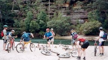
| When you reach the creek, turn left and head towards a large sandy beach - watch out for where dickheads have smashed bottles - and cross over the shallow end of the Duckhole. Alternatively, if you turn right when you reach the creek, it's only 50 metres till you can scramble over some rocks and trees for a dry crossing. Head left (upstream) when you are across and you'll end up back at the wet crossing. You win some you lose some, because this side of the creek is much more overgrown. |
|
Water from the Duckhole used to be pumped out to Glenbrook to provide water for the railways and in droughts. A pumping station used to exist on the eastern bank of the creek, and the track out follows the path of the old coal chute and coal supply track. Some remains of this system can still be seen, and there's still the odd lump of coal lying by the track.
The climb out heads basically straight up from the Duckhole, and starts out unrideable. Soon the track zigs and zags with some short rideable sections until finally reaching the top and more singletrack. Expect to push most of the way. Take this track to the railway line.
Turn right after following th railway fence, and descend steeply back into a gully (not back the way you've gone, the turn veers right just before the drop to the old rail crossing). Watch out for the logs across the track at the bottom of the hill (I wonder if they're still there). Then it's a short, steep, very overgrown climb until you meet a cross track. Here, I go right, until I come up almost in someone's back yard. I think you can go straight up without getting into their yard, but I prefer to follow a track to the right about 50 m, then turn left, and left again, which takes me back to the road outside the original house, and keeps me well out of their yard. Follow this road until you can turn left over the railway line bridge, then turn right to head to the station.
Whether you've gone to Glenbrook, or headed back to Woodford for that refreshing coffee, you should be tired, but with a big grin on your face. I really enjoyed my last go!
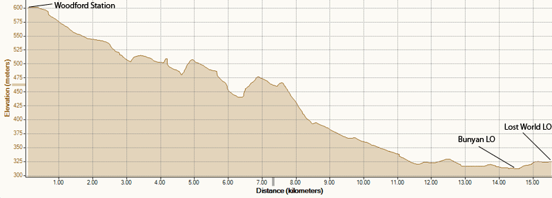
Elevation chart - Woodford station to Bunyan and Lost Word Lookouts (one way)
Recommended - this
ride retains
four fat hippies
![]()
![]()
![]()
![]()
All rides are now rated in Fat Hippies
- one means grab a slice of pizza and stay on the beanbag, two means not bad,
three means well worth a ride, four is a great ride and five means stop looking
at your computer, go ride it!
| Distance | ~30 km Woodford to lookouts and back, ~28 km Woodford station to Glenbrook station, including lookouts, ~20 without going to lookouts, but that's just silly |
| Type | Narrow firetrail and singletrack |
| Difficulty | Medium/Hard - some walking, some very overgrown. Not suited to new riders. Helmet and protective glasses strongly recommended - lots of low branches and overgrowth on the singletrack to the lookouts. Surface often loose. Quite a bit of deep sand. Some very technical sections in the Glenbrook extension. |
| Time | Varies - from a couple of hours to all day |
| Trains | Woodford, Blaxland, Glenbrook - timetable |
| Interest | History of Blue Labyrinth area, views |
| Issues |
|
| See also... | Anderson's fire trail, Murphy's Glen, Ingar, The Oaks |
| Maps | CMA Penrith 9030-3-N - 1:25000
(most of ride) |
| Ridden | October 2015 (lookouts and back) |
![]()
another fAt hIpPy production
