Blue
Mountains mtb rides
Anderson's Fire Trail
Anderson's fire trail (Ando's) stretches from Wentworth Falls to Woodford, and can be combined with the Woodford to Glenbrook (Oaks) fire trail for a long day ride of around 60 kms of dirt. There are a number of other rides in the area, including the shorter Ingar fire trail, which also goes to Woodford - but is unfortunately partly open to cars - and the ride out to McMahon's Point, where there are great views over Lake Burragorang - otherwise known as Sydney's water supply, Warragamba Dam.
The ride in along Tablelands Road marks the western edge of the huge fires of Christmas 2001. The country Ando's passes through was completely burnt out in those fires, but you wouldn't know it now. The start of Ando's was burned again in late 2009, and there's been a burn off in May 2013.
To get there, catch the train to Wentworth Falls, get off on the southern side, cross the highway, and head back towards Sydney on the cycleway/footpath. After you've gone back about 2 kms, you'll see Tablelands Road off to your right. There's a garden pot place on the corner. If you find yourself heading down Boddington Hill, you've gone too far - the turn off is at the top of the hill.
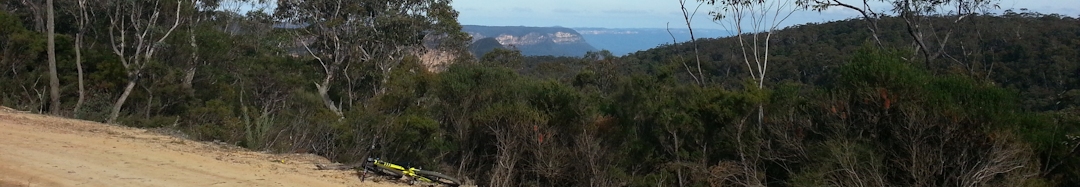
Tablelands Road has some of the best views in the mountains - start by ducking left at the Ingar turnoff and make your way to the Kings Tableland aboriginal site - lots of axe grinding grooves and fantastic views to the city and south. The access track is now blocked and marked "Private Property", but someone has cut a walking track a little further down the Ingar Road beside the park entrance sign, on the right hand side. The aboriginal site is wholly within the park. One time I was here, I saw a huge flock (hundreds) of yellow tailed black cockatoos - even if you don't see them, you'll often hear the cries of these majestic birds.
When you're finished here, head back to Tablelands Rd and turn left (south). About 500m before the communications towers, there's a track to the right that splits into a few tracks worth following. These tracks are short overgrown firetrails that lead to the edges of the ridge, offering views of Mt Solitary, Narrowneck Plateau, and the cliff faces of Leura and Wentworth Falls. If you make it to the right spot, you'll even make out the backs of the Three Sisters, as well as bush views that go on forever - very nice indeed.
Head back to Tablelands Road and turn right. Opposite the turnoff to the towers is a track to the left, which ends in a little clearing, which has good views to the city. Judging by the numbers of old plastic bottles and bits of hose I saw, it's a popular "Inspiration Point"... Back to Tablelands Road and turn left. Go straight past Queen Victoria Hospital, where the road turns to dirt. Don't veer right at the hospital or you'll end up in a Sydney Catchment Authority restricted (and patrolled) catchment area.
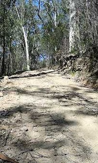
The dirt road heads mainly down, but is very corrugated in spots in June 2013 - if anybody finds my rattled out fillings, let me know... And I was on a duallie!
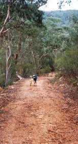
Just over 7 kms past the hospital, as you go around a right hand bend, you'll see a signposted track off to the left, with a gate across it - the gate's about 50 metres up the track. This is Anderson's fire trail. Not very far in, there's a fork in the trail - take the right hand track - even though the right hand fork looks less used and more overgrown, the left is a dead end. From then on, just follow the track.
WARNING: About 4 kms in, there is a fast downhill blat, with a blind left hand corner at the bottom. In their wisdom, NPWS have placed a gate around this corner. Since the fires, the gate's been open - I guess because the warning signs that finally appeared were burnt. The gate may well end up locked again. The gate has been open on all my recent rides.
Andersons has many waterbars
to jump, and is quite loose in sections. Top fun! The downhill to the creek
is currently fast and loose with plenty of air opportunities - if you're game... If
you get off the main line, it gets more than a little hairy as you're confronted
with lots of loose baby head rocks. Hope your suspension and brakes are working!
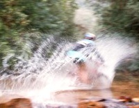
My brakes actually sizzled as I crossed the creek. If you get down without a big grin on your face, there's no hope for you...
Typical of most Blue Mountains fire trails, Anderson's has some ridgetop, some downhills (video 32 seconds 1029 KB), some valleys, some creeks, some climbs and some good views. Mostly, it's downhill to the creeks. Hang on tight for an exciting, adrenaline charged rush down the steep, very bumpy, very loose downhill before crossing at the junction of Queen Victoria and Bedford creeks, where you can splash through spectacularly. Luckily the hidden log of slipperiness is still there to catch the smarties... |
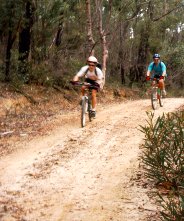
Mark Hodges photo Wildtrek Photography |
 |
Ride alongside the creek for a kilometre or less,
then follow the track right through the next creek crossing
for the climb up to Woodford. There's a concrete ramp either
side. If you don't cross the second creek, you'll be heading back
to Wentworth Falls
via the
monstrous
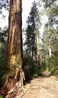
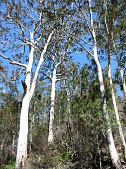
hill of the Ingar track. The creek crossings are a great place to stop and catch your breath, and to take on fuel in preparation for the big climb out. Check out the massive gum trees and listen to the bellbirds while you stop. In summer you can go in for a quick dip, or in the cooler months, just enjoy the peaceful surroundings and watch the patterns of sunlight on the water. |
The hill out of Bedford Creek is horrendous - well maybe not that bad, but it is h-u-u-u-g-e. It's 3 km from the creek to the next gate at the top of the ridge, and nearly all of that is uphill. These days, with lots of stops, heavy breathing, a red face and low gearing (22/32), I have almost ridden the whole way, once... and am full of admiration for anyone that goes the whole way without stopping! If it's going to rain on the ride, it's sure to be as you climb this hill... Just after the gate at the top of the hill, turn left for Woodford - a few more kilometres of hills, but at least they're smaller. Right takes you down to Murphy's Glen, a nice campsite and dam, but another monstrous climb back out. According to Google Earth, you'll have climbed 150m by the gate, and 200m by the station. |
|
When you reach Woodford station (Anderson's runs into the road that runs to the station), you have a couple of choices - head home on the train, or duck around to the Woodford to Glenbrook fire trail (The Oaks) for another 25 k or so of dirt.
Despite another reviewer's comments, this track isn't a twin to the Oaks. I find it much harder and hillier, you don't get that nice and easy 5 kms of downhill, and there's no singletrack! What you get instead are views, some big, long, fast and loose downhills, some killer uphills, waterbars and loads of fun/hard work.
I had an enjoyable couple of hours out here The track is fast becoming narrow again, and a single line is appearing in many places. The road in is still very corrugated, and the track surface very loose and rocky in places. I had a ball, the hairy run down to the creek only increasing the grin factor.
Views, waterbars, and a fast downhill, this ride scores 4 fat hippies
![]()
![]()
![]()
![]()
All rides are now rated in fat hippies - one means grab a slice of pizza and stay on the beanbag, two means not bad, three means well worth a ride, four is a great ride and five means stop looking at your computer, go ride it!
| Distance | approx 40 km |
| Difficulty | Medium/Hard
- may need to walk some uphills, uphill from the creek is a
doozy! Surface often loose. |
| Time | Varies |
| Trains | Wentworth Falls, Woodford |
| See also... | Woodford
to Glenbrook Fire Trail, Murphy's
Glen, McMahon's Point, Ingar Trail, some sidetracks |
| Ridden | Descember 2014 |
![]()
another fAt hIpPy production