Linden Ridge
This track has some similarities with Faulconbridge Point - it's an out and back firetrail along a northerly ridge, the actual dirt distance is fairly short, there's lots of waterbars (aka: jumps) for big air opportunities and there's more difficult tracks off to the side to explore. There the similarities end. Although there are views, they aren't as spectacular, and tend to be hidden through the trees. This track is quite hilly, and the waterbars are bigger, faster and more fun.
Getting there
There's a few km of road riding from Linden station before the start. Not all trains stop at Linden, and it's best to get in a carriage towards the rear of the train, as the first carriage often stops past the station - easy enough to jump off if you're young and fit, but much harder with a bike! Don't go up the stairs - head west to the end of the platform (towards Katoomba), where you'll see a pedestrian crossing over the line back to Sydney. Cross here and go down to the road. Head west along the road, and you'll soon climb a largish hill past King's Cave (signposted). Another small hill and you'll see a small playground on the right, and a right hand turn into Glossop Rd.
Turn right into Glossop Rd and follow it till the end. About a kilometre past the playground there's a gate blocking the road, and you'll see the turn-off to Linden Observatory on the right (note: if you drive, there's almost no car parking available at the gate - probably better to park a bit further away). Go round the gate, and you're into Water Board land. Follow the tar road to the water tank. On the way out, the big downhill from the tank can be very fast - although it's signposted at 20... Watch out for walkers, or, like the last couple of times I've been out here, skaters.
| As you zoom down the winding hill or crawl up the other side, you might notice a lake in the valley to the left - this is Lake Woodford, which used to be the sole water supply for the area. There's a couple of lookouts with good views of the lake.The lake surrounds (including the track running alongside the lake) are now accessible, but the lake itself, and the dam wall, remain strictly off limits - big fines apply. | 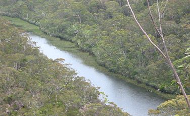 |
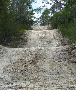
When you reach the water tank (and ubiquitous mobile phone tower), the dirt begins. You've now come nearly 2.5 kms from the playground. Turn right, and you're away!
The ride
There's a track off to the left at the gate, but unfortunately, it doesn't don't link up with the newly legal Lake Woodford tracks without crossing the catchment.
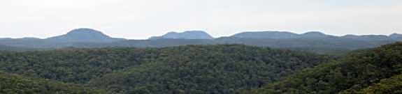
About 50m along the main track, there's a lookout off to the left, which offers great bush views to the west. The waterbars start immediately, but I need more speed to turn them into jumps. Fortunately, this doesn't take long!
Shortly, there's a track heads off to the right past an old water tank and the remains of a building. This gives a short singletrack bypass to the main track, rejoining after about half a km.
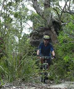
Approximately 2 km from the gate, as we round a 90 degree bend, we come to the first long singletrack (Mt Twiss). The singletrack runs off the main track to the left past a fallen tree. This track starts with some very steep waterbars designed to keep 4WDs out (apparently succeeding) and runs for some 5.5 kms before finally petering out. In summer, I find this quite hard - it's hilly, very overgrown in spots and there are lots of loose rocky sections. Winter is a much better time for the ride. I can usually ride all the way out, but end up walking a few hills on the way back. From the rocks at the end, you can see north across the Grose Valley to what must be Bilpin, and west to Mt Hay. Dec 2011: I turned back after 100m - this track was way too overgrown to ride. It might open up a bit further out, if you want to try. |
 |
This singletrack is another track where eyewear and helmets are strongly recommended - last time I rode it I had fresh scratches on my sunnies and a big gouge out of my helmet from a low branch trying to take me out! I was also covered with small scratches from brushing past bushes. On the way back there were some fun downhill runs in the more open areas, but you still need to be careful and look for hidden rocks and loose sticks amongst the leaf litter, as they can flick up and damage derailleurs and spokes.
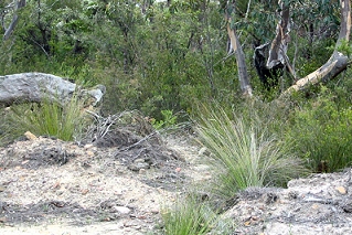
It's a fairly slow singletrack to ride - lots of low and mid range riding, very little high range, and lots of dodging around and under plants. Although there's always tracks on the firetrail, you don't see many bike tracks or footprints on the singletrack, so it's fairly remote - be careful.
This track is a bit more popular these days, although still very overgrown, there's a distinct trail most of the ride, and it's become a bit faster as the surface packs down - if you like overgrown tracks, this is well worth a look.
 |
Back on the main track, continue out and down over more waterbars. Jumps, jumps, and more jumps - some fast, some slow, some huge, and some just rollovers. Honestly, I reckon this track has more jumps than most others I've ridden in the mountains! Better riders than me could really get some huge air along here - just watch out for your collarbone... |
| There's another out and back singletrack around 3 kms past the first hairpin, also on a big hairpin. This singletrack runs less than a kilometre to a small (dry) dam, or you can take the right fork and continue much further. Again, fine overgrown singletrack, some technical stuff, great views and cool rock formations. You'll need your eye protection! |  |
Eventually the fun on the main track ends at the bottom of a hill, and you have to turn around and come back the way you have come. Some of the jumps still work but there's more uphill in this direction. There's actually another steep new singletrack which has appeared out the end, and you can see more steep firetrails on the other side of the deep gorge. According to my map, that must be the track running off from the helipad on Faulconbridge Point. Maybe they join, I'll leave you to confirm that - looked like too much walking and climbing for me!
| Linden Ridge
is quite a mixed bag, with something for new and experienced riders alike.
|
 |
4 fat hippies
![]()
![]()
![]()
![]()
All rides are now rated in Fat Hippies - one means grab a slice of pizza and stay on the couch, two means not bad, three means well worth a ride, four means a great ride and five means stop looking at your computer, go ride it!
| Distance | ~26 km station to station (out and back ride) |
| Difficulty | easy/medium firetrail, medium/hard singletrack. May need to walk some uphills. Surface currently loose, rutted and sandy. Lots of waterbars! Singletrack *very* overgrown and covered in leaf litter. |
| Time | Variable - depends on how much exploring you do! |
| Trains | Linden |
| Facilities | There are NO shops or facilities in Linden. Possibly water on railway station. |
| Maps | CMA
maps Springwood 9030-IV-S - 1:25,000 (my copy is very old) |
| See also | Oaks fire trail |
| Interest | Nearby King's Cave and Caley's Repulse, lots of flowers spring and summer |
| Ridden | December 2011 |
| Reviewed | January 2005, updated dec 2011 |
![]()
another fAt hIpPy production