Blue
Mountains mtb rides
Six Foot Track
This review is well out of date - please use as a rough guide only |
Warning, warning:
Once again, I have been contacted by the Administrator of the Six Foot Heritage Trust. He has provided the following information (as at 7/11/07):
"At present, this is what’s permissible for MTB’s on the Six Foot Track:
- from Jenolan Caves Road to Cox’s River Camp Ground, no restrictions.
- from Cox’s River Camp Ground to Megalong Valley Road, open on an ongoing trial basis using the old track alignment on the eastern side of the river.
This is what’s not permissible:
- no MTB’s on the single line track from the Camp Ground to the Swing Bridge (western side of the river).
- no MTB’s on the swing bridge (this is most important).
- no MTB’s on the track between Katoomba and the Megalong Valley Road.
- no MTB’s on the track between Jenolan Caves Road and Jenolan Caves.
So it is expected that riders will stick to the loop from the Jenolan Caves Road through to the Megalong Valley Road and then up to Blackheath, although not using the single line track & swing bridge. (The single line track and swing bridge are definitely off limits to MTB’s)."
I don't think he can get much clearer than that. PLEASE respect our right to travel on this track by complying with the above restrictions. The Trust is in discussion with mtb groups, but if riders flout the restrictions, the Trust sees no alternative but to bar us altogether. Don't let this happen!
Old notice:
Due to the alleged poor behaviour of some riders, this track is again in danger of being closed to mountain bikes. The Manager of the Six Foot Track Heritage Trust has contacted me personally to ask for support from mountain bike riders by acting responsibly. He would prefer we take the turn back up the public road to Lowther from the cattleyard area, before we reach the river. Complaints he has received from bushwalkers and landholders, together with the evidence he has seen indicate that riders are not sticking to the track, are skidding, and are riding around the stairs on the singletrack, leading to large eroded areas, rather than carrying their bikes down/up the stairs. Fences have been broken as well as other damage.
While I don't acccept that all the damage has been caused by mountain bike riders, we must show we are responsible and able to respect the track if we want to continue to use it. If you ride any of the singletrack sections, you MUST stick to the track, don't ride around stairs, don't skid and do ride lightly. Here's a link to an NPWS Code of Conduct for mountain bike riders - READ IT!! Thankfully, he has chosen to enter into discussions with mountain bike riders before implementing any bans.
If you are unable to ride responsibly, don't ride this track... - or any others I promote, for that matter...
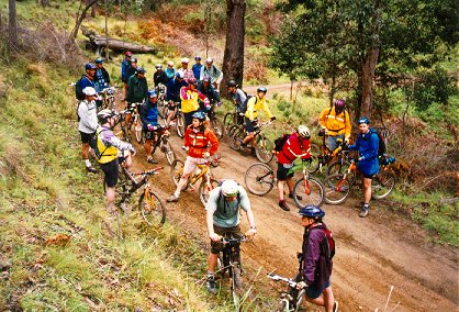
For mtbers, the best part of the Six Foot Track runs between Black Range, near Jenolan Caves, and Old Ford Reserve, Megalong Valley. This way, you go down the steepest of the hills, and avoid the worst of the steps (lots and lots) in the ride up to the Explorer's Tree at Katoomba.
This ride offers a bit of everything - steep gnarly downhill firetrail, huge climbs, flat out downhills, waterbars, beautiful singletrack, creek crossings and a suspension bridge.
You start from the picnic area on Jenolan Caves Road and climb for about a kilometre before turning right onto the track itself. Typical schlerophyll forest, and a nice smooth downhill firetrail with lots of waterbars for jumping. The track deteriorates the further you go, with lots of loose rocks and small drop offs.
Soon you reach the Pluviometer (some sort of water gauge thingie - it's on the map), where the first serious downhill is encountered - not much of a line, tight corners, very loose and rocky, very steep. There's lots of waterbars on this hill too, but many of the landing zones are loose and eroded. Good brakes are essential!! Most of the riders I was with complained of sore hands from squeezing the brakes so hard...
After riding around 13 - 14 km from the road, you're at the bottom and splashing through one of the three creek crossings - expect to get wet feet. In this section, the firetrail winds along following creeks, past several fantastic camp sites.
Climb
the Mini Mini Range and as you come into pastureland, it's flat out down the
very steep smooth firetrail and all its waterbars.
It's very easy to get air here - despite
braking hard over one waterbar,
I still jumped... Be careful, the surface is typical of tracks in granite country,
in that it's a hardpack base covered in those little rocks the size of ball bearings
and about the same amount of grip. Watch out for the sharp corner at the
bottom of the hill and the erosion gully that runs across the track - kerthump!
Watch
for the waterfall on the left on the next big downhill, very pretty, but
most of our group missed it as they whooshed past.
Eventually the downhill ends at the Cox's River, where you have to wade across and head left up the singletrack on the eastern side up to the wire suspension bridge. No bikes on the bridge.
By
this point of the ride, I was feeling pretty cranky, as I'd had several
mechanicals, but I was cheered up by the singletrack, despite some stairs.
The singletrack is cut high into the river bank, and sinuously winds its
way along the curves of the river. I really enjoyed this beautiful
section, with the river gushing over granite boulders below me, and had
a huge smile by the time we reached the bridge, my bad mood gone.
After the bridge, there's a long singletrack climb back to Old Ford Reserve in Megalong Valley, where you can arrange to be met, or you can ride up the narrow, winding, tar road to Blackheath!! This singletrack starts by winding alongside the river before climbing the mostly rideable hills to Megalong Valley. There are some steps where you'll have to carry your bike, but they don't go on too long. Some of this section crosses farmland, so stay on the tracks, and always leave gates as you find them. As you climb to the reserve, you get fantastic views of the western side of Narrowneck. Looks excellent in the afternoon sun.
Some
people just do this stretch as their ride - they park at Old Ford Reserve, and
ride down to the bridge, do the singletrack and ride back - I
think this is about 8 kms each way. It's quite a rocky track in parts, balanced
with smooth farm tracks, and I think it would be a great shorter ride.
| Distance | ~28 km |
| Difficulty | Hard. Very steep hills. Surface loose and/or rocky in many places. |
| Type | Fire trail, lots of waterbars, singletrack, farm tracks, stairs |
| Time | Varies - took us 5 hours - but only 2 hrs 30 riding time - allow all day |
| Trains | Impractical,
but Lithgow and Blackheath the closest - timetable The easiest is a two car shuffle, or a friend who will play shuttle driver |
| Interest | Historic track, suspension bridge |
| Issues | Popular
with bushwalkers, slow down and say hello, ride lightly, don't skid down the hills. BEHAVE! |
![]()
another fAt hIpPy production